E4 Long Distance Path
Discover the E4 long distance path in Cyprus. Find out where the best sections are and where to plan a Cyprus walk or bike ride.
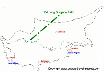 Cyprus E4 route Map
What is the E4?
The E4 is a European long distance path which starts in Gibralter and ends in Cyprus.
The entire route covers 10,450 kilometres and the Cyprus section, which was added to the route in 2005, is 640 kilometres long.
The E4 also goes through Spain, France, Switzerland, Germany, Austria, Hungary, Bulgaria, Greece (mainland) and Crete, the only other island on the route. You obviously have to jump on a boat or a plane if you want to walk the entire route via Crete and Cyprus. The Cyprus section alone will take at least two weeks to complete assuming you are a keen walker capable of covering 45-50km per day.
E4 Long Distance Path Walking Route
 E4 waymarker
In Cyprus, the E4 links the two airports on the south of the island at Larnaca and Paphos. The route is a cross country one and, whilst it misses many historic sites and areas of natural beauty, it does lead you through some of the most scenic areas on the west of the island on the Akamas peninsula and in the Paphos forest areas.
The route map above shows the E4 route outline but if you get hold of a copy of the FREE map of the island from the Cyprus Travel Organisation (tourist information), you will be able to see the E4 highlighted with a dotted GREEN line.
Cyprus Walking Trails - Best sections of E4
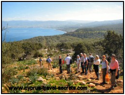 Aphrodite Trail - part of E4
My favourite sections of the E4 are on the west of the island.
First, there is the section running from Pegeia to the Baths of Aphrodite. This section of the E4 takes you past lovely Lara bay and then on through the Akamas peninsula. The scenery here is wild and rugged and it is also one of the best places to look for wild flowers during springtime.
Another beautiful section of the Cyprus E4 long distance path is from Stavros tis Psokas to Lysos. A long section covering some 28km, this part of the route hugs the Stavros tis Psokas river where wild moufflon snuffle in the undergrowth, hidden from view by the vast pine tree forest cover.
Tip: If you are lucky you will spot a moufflon, a far bigger thrill than going to the moufflon enclosure at the Stavros forest station.
After reaching the deserted village of Sarama, the route ascends through several other deserted villages and finally comes out at Lysos village where you can get a well earned coffee and snack at the village cafeneio.
Walking the E4 Long Distance Path
Please note that some of the route is actually on tarmac or concrete roads. While these are usually quiet, they are not as scenic as taking, in my view, a far more rural option. Perhaps marking the route in a 4x4 wheel drive is to blame?
Tip: Large parts of the E4 long distance path in Cyprus route cross remote and uninhabited forest areas, especially near the Troodos mountains, so make sure you carry sufficient water and food supplies with you.
If you plan to try and walk the entire E4 trail, please note that you will need to do a LOT of planning on where to stay along the route. While some sections are close to villages with Agrotourism style lodges, other remote forest areas may require camping at one of the island's campsites.
I suggest you get hold of a map of the island from the tourism department, plan which sections to walk and then search for accommodation along the way, pre-booking in advance to ensure lodges are open.
Related Pages:
Camping in Cyprus, when walking the E4 trail
Horteri Trail - nature walk on Akamas at Stavros forest station
Atalante and Artemis Trails in the Troodos
Back to Cyprus Walks from E4 Long Distance Path
Back to Cyprus Travel Secrets Home from E4 Long Distance Path


Favourite Things to Do


New! Comments
Have your say about what you just read! Leave me a comment in the box below.